Best GPS for Hikers of 2026
An authoritative technical analysis of the most reliable Global Navigation Satellite System (GNSS) handhelds and wearables engineered for backcountry navigation and emergency communication.
Introduction
Modern backcountry navigation has evolved beyond simple coordinate plotting into a sophisticated ecosystem of Multi-Band GNSS (Global Navigation Satellite Systems) and integrated satellite communication. For hikers, the choice of a GPS device is no longer merely about knowing one’s location; it is about maintaining a reliable link to rescue services via the Iridium satellite network and ensuring signal lock under challenging conditions like deep canyons or heavy canopy. While smartphones have made significant strides in mapping, dedicated GPS units offer superior ruggedness, longer battery life, and specialized antennae that outperform multi-purpose consumer electronics.
When evaluating a dedicated navigator, technical specifications such as multi-band support - which utilizes both L1 and L5 frequencies - are paramount. This technology mitigates multipath errors, where signals reflect off terrain and create positional drift. Furthermore, the integration of an ABC sensor suite (Altimeter, Barometer, and Compass) provides critical atmospheric data and orientation that does not rely solely on satellite movement. Our selection focuses on devices currently manufactured and supported, representing the peak of navigation engineering and mechanical durability.
Best for Remote Expeditions: Garmin GPSMAP 67i
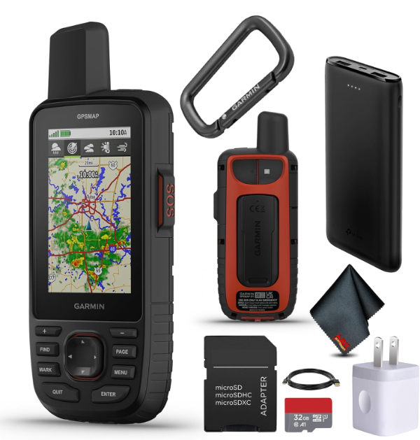
The Garmin GPSMAP 67i stands as the current benchmark for comprehensive expedition navigation. It integrates Garmin's inReach satellite technology, allowing for two-way messaging and SOS functionality via the Iridium network. This device utilizes multi-band GNSS, which significantly improves accuracy in high-latitude or deep-valley environments by accessing multiple satellite frequencies simultaneously. Its thermal, shock, and water performance is certified to MIL-STD-810 standards, ensuring it functions in environments where consumer smartphones typically fail.
Technically, the 67i is a powerhouse of power management. In standard tracking mode, it provides up to 165 hours of battery life, which can be extended to 425 hours in expedition mode. This is achieved through a high-efficiency lithium-ion internal battery and optimized polling intervals for satellite pings. The transflective 3-inch color display is engineered specifically for high-glare environments, relying on ambient light to illuminate the pixels, thereby reducing the power draw from the backlight.
The primary limitation is the ecosystem lock-in; the inReach features require an active satellite subscription to function. While the device comes preloaded with TopoActive maps, users who prefer proprietary third-party mapping may find the storage-management software somewhat antiquated. However, for those requiring a "one-and-done" safety and navigation tool, the 67i has no true peer in the current market.
The GPSMAP 67i utilizes L5 frequency signals, which have a higher power and wider bandwidth than the standard L1 signals. This allows the receiver to better distinguish between the direct satellite signal and signals reflected off trees or rocks, resulting in sub-3-meter accuracy in environments that typically cause "signal bounce."
Best Large-Screen Navigation: Garmin Montana 700i
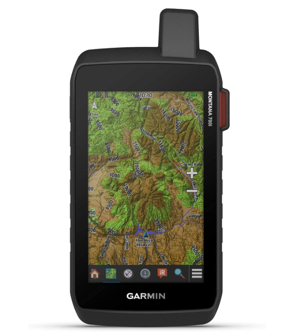
The Garmin Montana 700i is designed for users who require a high-resolution, 5-inch touchscreen interface without sacrificing the ruggedness of a dedicated GPS. It is a crossover device that bridges the gap between handheld hiking units and vehicle-mounted navigators. Like the GPSMAP 67i, the Montana 700i includes inReach satellite communication technology. The screen is dual-orientation and glove-friendly, making it suitable for winter mountaineering or technical terrain where button navigation might be cumbersome.
From a hardware perspective, the Montana 700i is distinguished by its City Navigator maps and TopoActive mapping versatility. It supports multiple satellite constellations, including GPS and GALILEO, and features a high-sensitivity antenna. The device is notably heavy, weighing nearly 15 ounces, which is a significant consideration for ultralight hikers. However, this weight reflects a robust internal chassis designed to survive significant impacts and immersion in water (IPX7 rating).
The main tradeoff is battery life relative to its screen size. While it offers 18 hours in GPS mode, the large display is a significant power drain. It also utilizes a proprietary lithium-ion pack, though an optional AA battery housing is available for those who prefer field-swappable power sources. This is the ideal unit for "overlanders" or search-and-rescue teams who need maximum map visibility and complex data fields on a single screen.
The Montana 700i meets IPX7 standards, meaning it can withstand incidental exposure to water of up to 1 meter for up to 30 minutes. This is achieved through ultrasonic welding of the casing and specialized gaskets on the battery compartment and charging ports.
Best Traditional Handheld: Garmin eTrex 32x
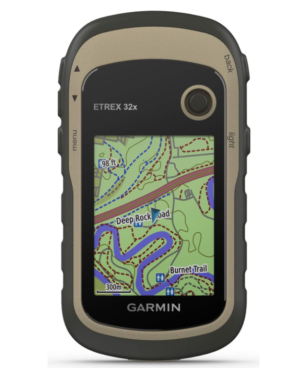
The Garmin eTrex 32x remains a favorite for purists who value compact size and the reliability of AA batteries. Unlike the more expensive GPSMAP or Montana series, the eTrex uses a thumbstick controller rather than buttons or a touchscreen. This design is intentionally minimalist to maximize battery efficiency and durability. It comes preloaded with TopoActive maps and features 8GB of internal memory, which is expandable via microSD for additional chart data.
Technically, the 32x supports both GPS and GLONASS satellite systems. By utilizing the Russian GLONASS system alongside the US GPS system, the device can lock onto 24 more satellites than with GPS alone, which is vital for maintaining a fix in high-latitude regions. It includes a 3-axis compass and a barometric altimeter, ensuring accurate orientation even when standing still - a feature often missing from entry-level GPS units that rely on movement to calculate heading.
The screen is small, measuring only 2.2 inches, and the resolution is low by modern standards. Furthermore, it lacks the multi-band (L5) support and satellite messaging capabilities of the higher-end models. However, its ability to run for 25 hours on two standard AA batteries makes it an excellent choice for long-distance thru-hikers who do not want to rely on portable power banks or solar chargers.
The 32x features a tilt-compensated 3-axis compass. Unlike 2-axis compasses, which must be held perfectly level to give an accurate reading, this electronic sensor compensates for pitch and roll, providing a correct heading regardless of how the device is held.
Best Multi-Band Accuracy: Garmin GPSMAP 65s
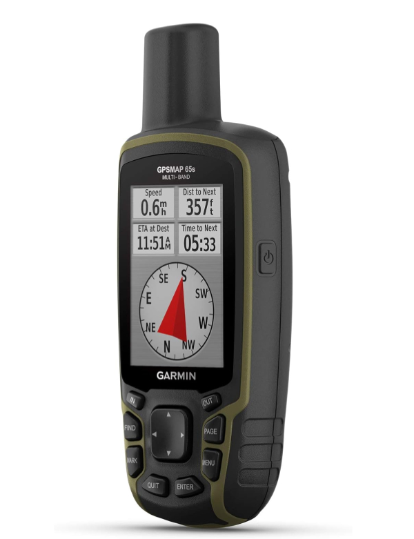
For hikers who demand the highest possible positional precision but do not need satellite messaging, the Garmin GPSMAP 65s is a specialized alternative. Its standout feature is the inclusion of multi-band technology across five satellite systems: GPS, GLONASS, GALILEO, QZSS, and IRNSS. This provides the most robust signal lock available in a handheld format, specifically designed for "urban canyons" or extremely dense forest where standard GPS signals struggle to penetrate.
The 65s maintains the classic button-operated interface of the GPSMAP series, which many users prefer for its tactile feedback in wet or cold conditions. It includes the standard ABC sensor suite and is compatible with the Garmin Explore app for route planning and data management. Unlike the 67i, the 65s runs on two AA batteries, providing a balance between the advanced antenna technology of the 60-series and the power flexibility of the eTrex line.
The drawback here is the lack of internal rechargeable power and the absence of inReach technology. It is a "pure" navigation device. If you find yourself in an emergency, you will still need a separate PLB (Personal Locator Beacon) or satellite messenger. It is best for technical hikers, geocachers, and surveyors who prioritize coordinate accuracy above all else.
By accessing the Japanese QZSS and Indian IRNSS constellations alongside standard systems, the 65s can maintain a fix in environments where the satellite "view" is partially obstructed by topography, as it has a higher probability of seeing satellites directly overhead.
Best GPS Watch Alternative: Coros Vertix 2S
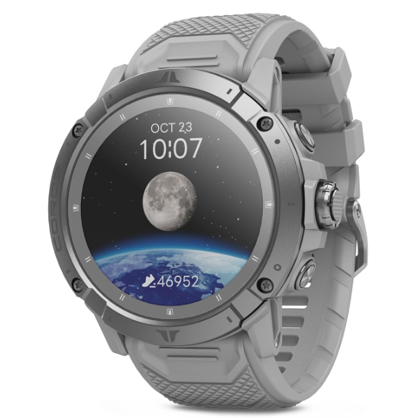
The Coros Vertix 2S is the only wearable on our list, chosen for its extreme battery life and sophisticated GPS chipset that rivals handheld units. For hikers who want to keep their hands free and maintain a constant log of their biometric and positional data, the Vertix 2S offers a compelling alternative. It features an "All Systems On" GNSS mode that communicates with all five major satellite constellations simultaneously and supports dual-frequency multi-band communication for high accuracy in technical terrain.
Technically, the Vertix 2S is defined by its efficiency. It provides 118 hours of continuous GPS tracking on a single charge, outlasting almost every other GPS watch on the market. The sapphire glass and titanium alloy bezel are rated for 10ATM (100 meters) of water resistance and can operate in temperatures as low as -22°F. It also includes global offline mapping with landscape, topo, and hybrid views that can be navigated via the digital dial.
The primary tradeoff of a wearable is screen size. Reading a topographical map on a 1.4-inch circular display is significantly more difficult than on a Montana 700i. Furthermore, it lacks the tactile buttons of a handheld GPS, which can be an issue when wearing thick mittens. It is best for "fast-and-light" hikers and mountain runners who prioritize weight and biometric data over large-scale map viewing.
The Vertix 2S uses a chipset that processes L1 and L5 frequencies. This allows the watch to correct for ionospheric delay - a common phenomenon where satellite signals are slowed by the earth's atmosphere, leading to significant positional errors in GPS watches without this hardware.
How We Chose These Products
Our selection process was based on three critical vectors: Signal Integrity, Field Reliability, and Communication Redundancy. We prioritized devices that offer more than just basic GPS connectivity, specifically looking for multi-band (L1/L5) hardware which is now the industry standard for technical navigation. We also evaluated "mean time between failures" based on user reports in extreme environments and prioritized devices with physical buttons or glove-compatible interfaces, as these are essential for safety in cold and wet conditions. Each device on this list is currently in production and represents a verified improvement over previous-generation hardware.
Comparison Overview
| Model | GNSS Type | Battery Life (GPS Mode) | Satellite Messaging | Weight |
|---|---|---|---|---|
| Garmin GPSMAP 67i | Multi-Band GNSS | 165 Hours | Yes (inReach) | 8.1 oz |
| Garmin Montana 700i | Standard GNSS | 18 Hours | Yes (inReach) | 14.5 oz |
| Garmin eTrex 32x | GPS + GLONASS | 25 Hours | No | 5.0 oz |
| Garmin GPSMAP 65s | Multi-Band GNSS | 16 Hours | No | 7.7 oz |
| Coros Vertix 2S | Multi-Band GNSS | 118 Hours | No | 2.5 oz |
Buying Guide: What to Look For
- Multi-Band (L1 + L5) Support: This is the most significant upgrade in GPS technology in the last decade. If you hike in dense woods or near cliffs, L5 support is essential to prevent "drift."
- Physical Interface: Touchscreens are intuitive but fail in the rain or with gloves. For serious winter or wet-weather hiking, tactile buttons are a safety requirement.
- Satellite Messaging (Iridium): If you hike alone or in areas without cell service, a device with inReach or similar satellite messaging can be the difference between a minor incident and a tragedy. Note that these require monthly subscriptions.
- Battery Chemistry: Internal Li-ion batteries are convenient and hold a charge better in cold weather, but AA-powered units are easier to keep running on month-long thru-hikes without a power source.
- Mapping Compatibility: Ensure the device supports "OpenStreetMap" or proprietary topographic maps that include high-resolution contour lines and water sources for your specific region.
General Pro / Cons
| General Strengths |
|---|
| Superior signal lock under canopy compared to smartphones |
| Extreme durability (MIL-STD-810) and waterproofing |
| Long-range emergency satellite SOS capabilities |
| Transflective screens are highly visible in direct sun |
| Specialized ABC sensors for high-altitude tracking |
| Field-swappable batteries in many models |
| Physical buttons for reliable operation in wet weather |
| General Weaknesses |
|---|
| High initial cost of hardware |
| Ongoing costs for satellite subscription services |
| Lower screen resolution than modern smartphones |
| Heavier and more bulk for ultralight hikers |
| Steep learning curve for advanced mapping features |
| Proprietary data cables often required for updates |
| Small displays can be difficult for detailed route planning |
Final Summary
Selecting a dedicated GPS is a critical decision for backcountry safety and navigational efficiency. For the majority of serious hikers, the Garmin GPSMAP 67i represents the most complete solution, offering peerless accuracy combined with life-saving satellite communication. If weight is the primary concern, the Coros Vertix 2S provides an incredible bridge between wearable tech and high-end positioning hardware. For those on a budget or embarking on long thru-hikes where power is scarce, the eTrex 32x remains a reliable, AA-powered classic. Regardless of the choice, a dedicated GPS should be viewed as a foundational tool that complements, but does not replace, the fundamental skills of map and compass reading.
Aggregate rating of the products reviewed: 4.74 out of 5.